years of experience
Extensive corporate project experience
As a GIS Specialist in a corporate setting, I'm driven by the potential of geospatial technology to optimize workflows and create automated solutions that make a meaningful impact. By combining my passion for custom tool development with expertise in GIS, data analytics, and web development, I streamline processes, enhance efficiency, and contribute to the evolving future of spatial data management and analysis.
From custom web maps to process automation, I build responsive applications that make spatial data accessible across devices.
Streamline organizational data processes by integrating Excel, SharePoint, Power Apps & Automate, BI, and other analysis tools.
Delivering geospatial insights, intelligent data systems, and custom web tools that drive informed decisions.
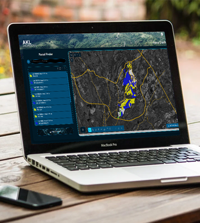
I develop rich, browser-based maps using platforms like ArcGIS Online, LeafletJS, and Mapbox GL JS. These interactive tools allow users to explore spatial data with fluid navigation, custom layers, and real-time updates.
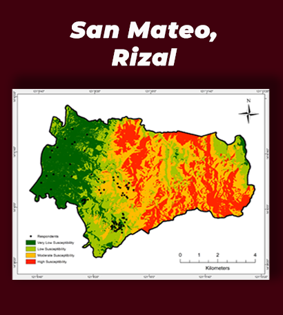
Using advanced GIS workflows, I extract insights from spatial data to support planning, decision-making, and asset management. From parcel mapping to spatial statistics, my work bridges data and geography.
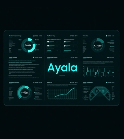
I create clean, insightful dashboards using Power BI and Tableau to transform raw data into meaningful visuals. These reports help stakeholders track KPIs, uncover trends, and interact with data dynamically.
I build responsive, fast-loading websites using HTML, Tailwind CSS, and JavaScript tailored to your needs. Whether it's for portfolios, internal systems, or project showcases, I prioritize performance and user experience.
From digital illustrations to print-ready materials, I use Adobe Illustrator and Photoshop to craft high-impact visuals. I design infographics and custom assets for both web and social platforms.
I streamline repetitive tasks and organize complex data using spreadsheets, SharePoint, and automation tools like Power Automate. I also build custom forms and lightweight apps through Power Apps to enhance team collaboration and data collection.
products and platforms through thoughtful design, intuitive development, and meaningful data storytelling.
utilizing GIS, Data Analytics, and Web Development for expert solutions to enhance decision-making, streamline processes, and drive organizational success.

Independent GIS Support: Acts as the sole GIS specialist for AKL Properties — the joint venture between ALI and Royal Asia Land, a subsidiary of Shangri-La Properties.
Lead a team of GIS professionals in delivering cartographic and real-time mapping solutions tailored to corporate requirements, with a focus on land acquisition and right-of-way projects.
Assist the Land Manager in managing the projects of the corporation in different areas of the Philippines through property development activities, financial planning, supervising of subcontractors, mapping, and database management.
Map out the commercial demands for Globe's services in the Philippines using various mapping softwares and assess the penetration factor of GTI's facilities to the target areas through competitor's presence mapping and evaluation of the municipality's socio-economic status.
College
High School

© . All rights reserved by Zaxus - Zac's Nexus.